Sold Archive
Africa - Continent
- Africae, described, the manners of their Habits and buildings…
- Sold
- Region: Africa & Oceana
- Cartographer: Speed, John
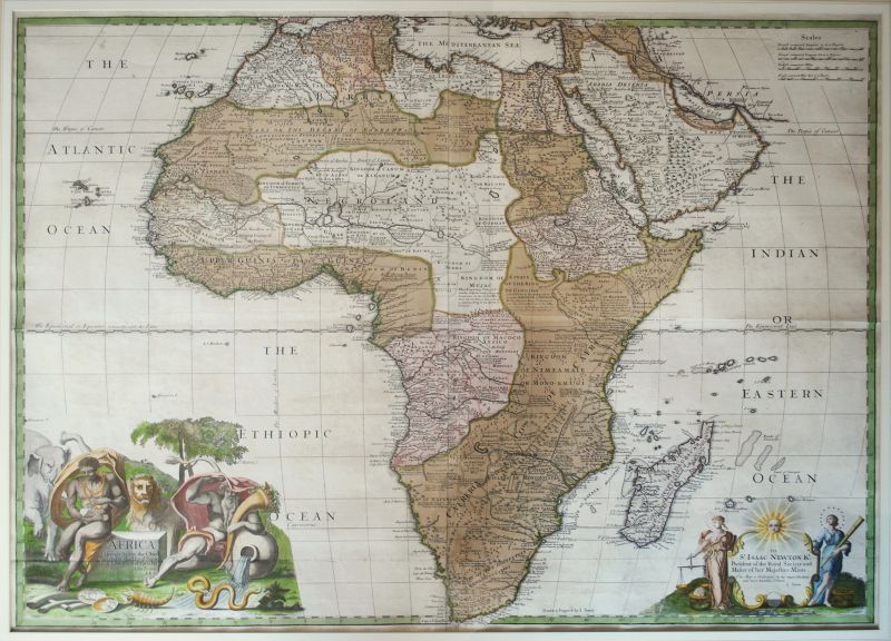
Africa - Continent
- Africa Corrected From Observations of the Royal Society of London and Paris.
- Sold
- Region: Africa & Oceana
- Cartographer: Senex, John
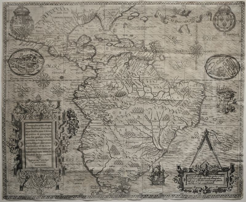
America - South - Continent
- Americae Pars Magis Cognita
- Sold
- Region: Americas
- Cartographer: De Bry, Theodore
Amsterdam
- Amstelredamum, nobile Inferioris Germaniae oppidum…
- Sold
- Region: Europe
- Cartographer: Braun & Hogenberg
Anglo-Saxon Heptarchy
- Englalond Anglia AngloSaxonum Heptarchia
- Sold
- Region: England
- Cartographer: Hole, William
Asia - Continent
- Asia With The Islands Adioyning Described
- Sold
- Region: Asia
- Cartographer: Speed, John
Asia - Continent
- A Generall Mapp of Asia
- Sold
- Region: Asia
- Cartographer: Blome, Richard
Baltic Sea, Scandinavia and Northern Europe - Sea Chart
- Nieuwe Wassende Graade Paskaart Over de Geeheele Oost-Zee
- Sold
- Region: Europe
- Cartographer: van Keulen, Johannes & Gerard
Belgium - Flanders
- Flandria
- Sold
- Region: Europe
- Cartographer: Ortelius, Abraham
Berkshire
- Comitatus Bercheriae vulgo Barkshyre…
- Sold
- Region: Berkshire
- Cartographer: Saxton, Christopher, Hole, William
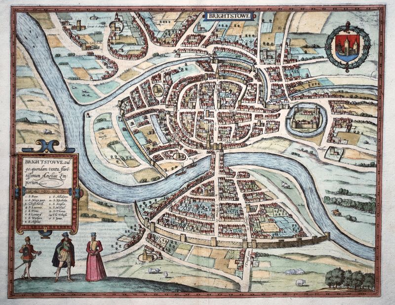
Bristol
- Brightstowe
- Sold
- Region: Cities & Towns
- Cartographer: Braun & Hogenberg
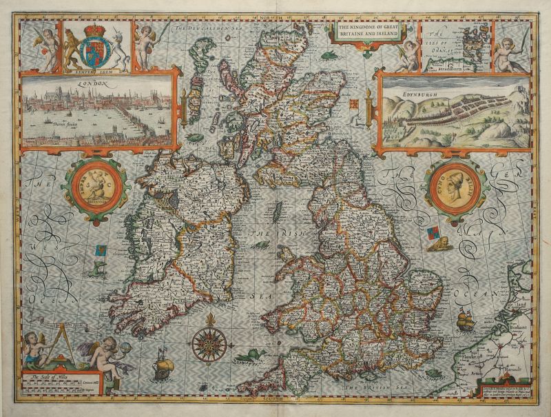
British Isles
- The Kingdome of Great Britaine And Ireland
- Sold
- Region: General British Isles Maps
- Cartographer: Speed, John
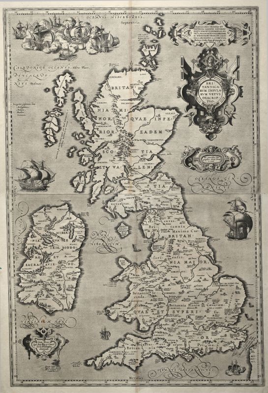
British Isles
- Britannicarum Insularum Vetus Descriptio.
- Sold
- Region: General British Isles Maps
- Cartographer: Ortelius, Abraham
British Isles
- Magnae Britanniae Et Hiberniae Tabula
- Sold
- Region: General British Isles Maps
- Cartographer: Blaeu, Willem & Joan
British Isles
- The Kingdome of Great Britaine And Ireland
- Sold
- Region: General British Isles Maps
- Cartographer: Speed, John
British Isles
- Britannicarum Insularum Vetus Descriptio.
- Sold
- Region: General British Isles Maps
- Cartographer: Ortelius, Abraham
British Isles
- The Kingdome of Great Britaine And Ireland
- Sold
- Region: General British Isles Maps
- Cartographer: Speed, John
British Isles - Saxon Heptarchy
- Britain As It Was Divided in the tyme of the Englishe-Saxons especially during their Heptarchy
- Sold
- Region: General British Isles Maps
- Cartographer: Speed, John
British Isles - Saxon Heptarchy
- Britain As It Was Divided in the tyme of the Englishe-Saxons especially during their Heptarchy
- Sold
- Region: General British Isles Maps
- Cartographer: Speed, John
British Isles - Saxon Heptarchy
- Britain As It Was Divided in the tyme of the Englishe-Saxons especially during their Heptarchy
- Sold
- Region: General British Isles Maps
- Cartographer: Speed, John
Buckinghamshire
- Buckingham Both Shyre, and Shire Towne described
- Sold
- Region: Buckinghamshire
- Cartographer: Speed, John
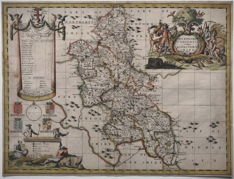
Buckinghamshire
- Buckingamiae Comitatus vulgo Buckinghamshire
- Sold
- Region: Buckinghamshire
- Cartographer: Seller, John
Buckinghamshire
- Buckingham Both Shyre, and Shire Towne described
- Sold
- Region: Buckinghamshire
- Cartographer: Speed, John
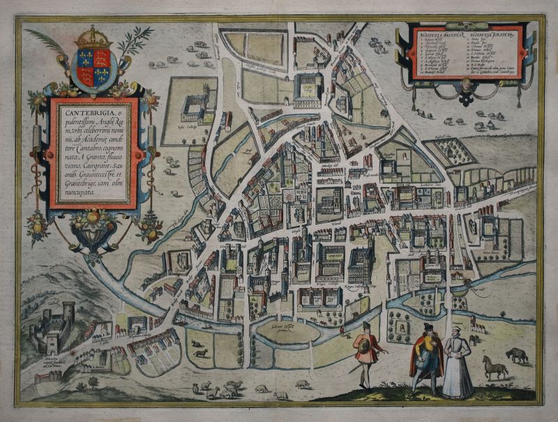
Cambridge
- Cantebrigia, Opulentissimi Angliae Regni…
- Sold
- Region: Cities & Towns
- Cartographer: Braun & Hogenberg
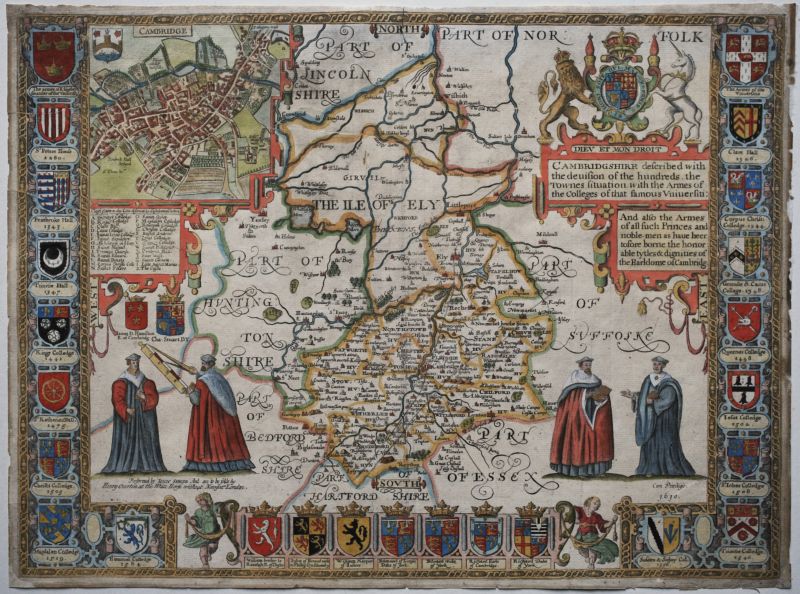
Cambridgeshire
- Cambridgshire described with the devision of the hundreds…
- Sold
- Region: Cambridgeshire
- Cartographer: Speed, John
Cambridgeshire
- Cambridgshire described with the devision of the hundreds…
- Sold
- Region: Cambridgeshire
- Cartographer: Speed, John
Canterbury
- Cantuarbury
- Sold
- Region: Cities & Towns
- Cartographer: Braun & Hogenberg
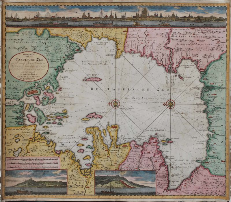
Caspian Sea
- Nieuwe Caart van de Caspische Zee
- Sold
- Region: Asia
- Cartographer: van Keulen, Johannes & Gerard
Celestial Chart
- Haemisphaeria Sphaerarum Rectae et Obliquae…
- Sold
- Region: World & Celestial
- Cartographer: Jansson, Jan, Cellarius, Andreas
Celestial Chart
- Planisphaerium Coeleste. Secundum restitutionem Hevelianam et Hallejanam.
- Sold
- Region: World & Celestial
- Cartographer: Schenk, Peter
Celestial Chart - Constellations
- Haemisphaerium Stellatum Boreale Antiquum
- Sold
- Region: World & Celestial
- Cartographer: Cellarius, Andreas
Celestial Chart - Constellations
- Haemisphaerium Stellatum Australe Antiquum
- Sold
- Region: World & Celestial
- Cartographer: Cellarius, Andreas
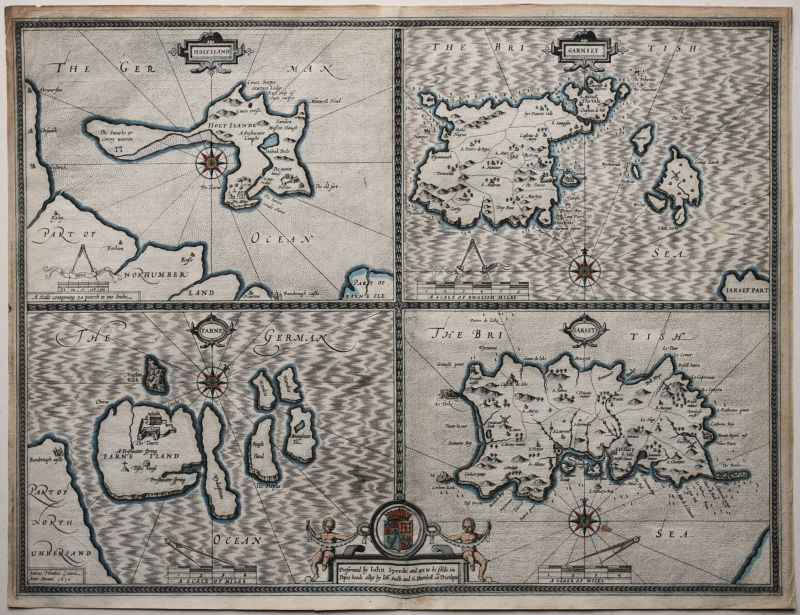
Channel & Other Islands
- Holy Iland, Garnsey, Farne, Jarsey
- Sold
- Region: England, Islands & Sea Charts
- Cartographer: Speed, John
Channel & Other Islands
- Holy Iland, Garnsey, Farne, Jarsey
- Sold
- Region: England, Islands & Sea Charts
- Cartographer: Speed, John
Cheshire
- The Countye Palatine of Chester with that most ancient citie described
- Sold
- Region: Cheshire
- Cartographer: Speed, John
Cheshire
- Cestriae Comitatus (Romanis Legionibus et Colonys olim insignis)
- Sold
- Region: Cheshire
- Cartographer: Saxton, Christopher
China
- The Kingdome of China
- Sold
- Region: Asia
- Cartographer: Speed, John
China and Central Asia - Tartary
- Tartaria
- Sold
- Region: Asia
- Cartographer: Hondius, Jodocus & Henricus
Connaught
- The Province of Connaugh with the Citie of Galwaye Described
- Sold
- Region: Ireland
- Cartographer: Speed, John
Constantinople
- Byzantium Nunc Constantinopolis
- Sold
- Region: Europe, Asia
- Cartographer: Braun & Hogenberg
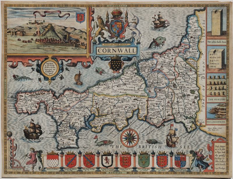
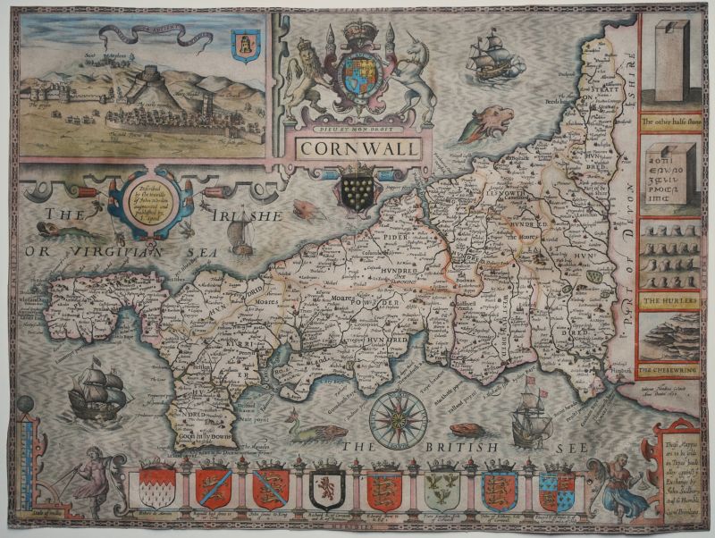
Cornwall
- Cornwall
- Sold
- Region: Cornwall
- Cartographer: Speed, John
Cornwall
- Cornwall
- Sold
- Region: Cornwall
- Cartographer: Speed, John
Cornwall
- Cornwall
- Sold
- Region: Cornwall
- Cartographer: Speed, John
Cornwall
- Cornwall
- Sold
- Region: Cornwall
- Cartographer: Speed, John
Cornwall and Southwest Coast of England
- Zee Caerte van Engelants Eijndt, alsoe hem Tselfde Landt Verthoont Beginnede van Sorlinges tot Pleijmondt…
- Sold
- Region: Cornwall, Islands & Sea Charts
- Cartographer: Waghenaer, Lucas Janszoon
Cumberland
- Cumbria Sive Cumberlandia Quae olim par Brigantum
- Sold
- Region: Cumberland
- Cartographer: Saxton, Christopher, Kip, William
Czech Republic - Bohemia
- Regni Bohemiae Descriptio.
- Sold
- Region: Europe
- Cartographer: Ortelius, Abraham
Denmark
- The Kingdome of Denmarke
- Sold
- Region: Europe
- Cartographer: Speed, John
Derbyshire
- An Accurate Map of Derbyshire
- Sold
- Region: Derbyshire
- Cartographer: Bowen, Emanuel
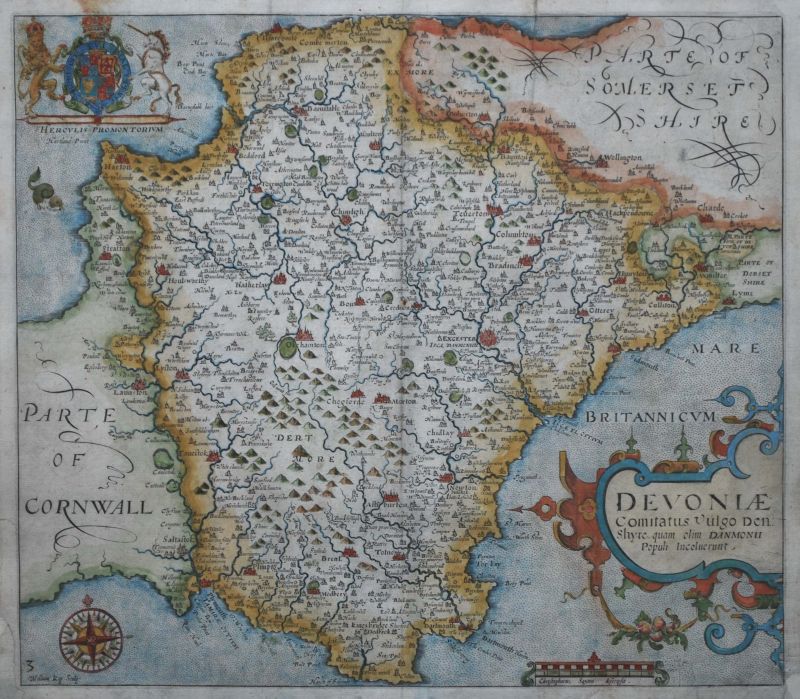
Devon
- Devoniae Comitatus Vulgo Den Shyre…
- Sold
- Region: Devon
- Cartographer: Saxton, Christopher, Kip, William
Devon
- Devoniae Comitatus Vulgo Den Shyre…
- Sold
- Region: Devon
- Cartographer: Saxton, Christopher, Kip, William
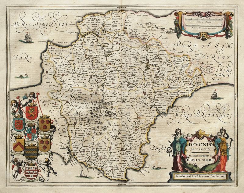
Devon
- Devoniae Descriptio. The Description of Devon-shire.
- Sold
- Region: Devon
- Cartographer: Jansson, Jan
Dorset
- Dorsetshyre With the Shyre-towne Dorchester …
- Sold
- Region: Dorset
- Cartographer: Speed, John
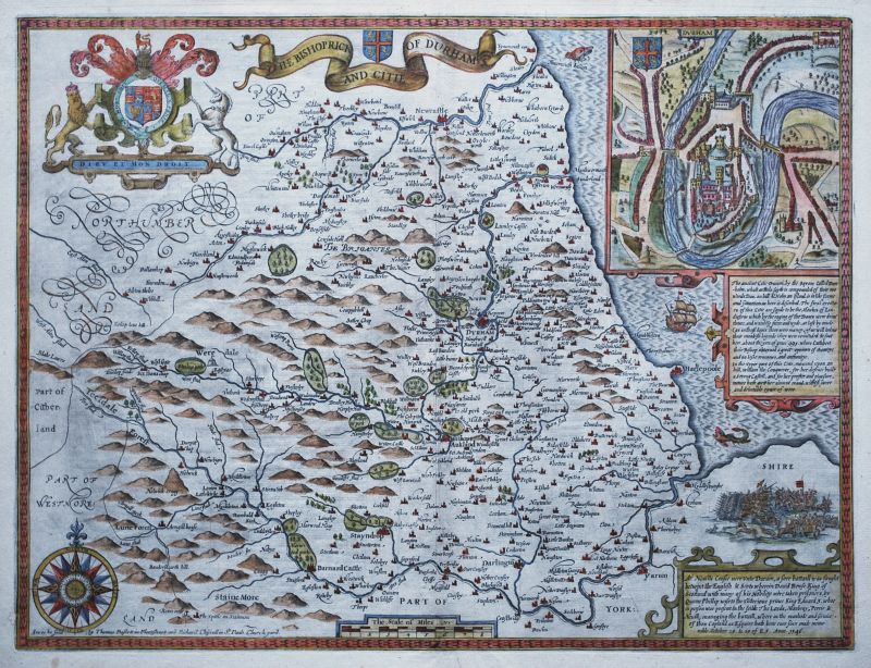
Durham
- The Bishoprick and Citie of Durham
- Sold
- Region: Durham
- Cartographer: Speed, John
Edinburgh
- The Plan of the City and Castle of Edinburgh
- Sold
- Region: Scotland, Cities & Towns
- Cartographer: Edgar, William
Edinburgh
- Edenburg – Edenburgum. Scotiae Metropolis.
- Sold
- Region: Scotland, Cities & Towns
- Cartographer: Braun & Hogenberg
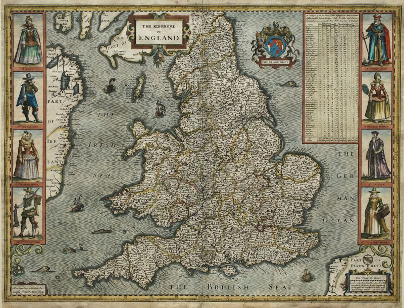
England and Wales
- The Kingdome of England
- Sold
- Region: England
- Cartographer: Speed, John
English Channel
- Pascaert van de Canael Tusschen Engelandt en Vrancryck, van Cales tot C. de la Hagu, als meede van Doever tot Poortlant…
- Sold
- Region: Europe, Islands & Sea Charts
- Cartographer: van Keulen, Johannes & Gerard
France
- France revised and augmented …
- Sold
- Region: Europe
- Cartographer: Speed, John
France - Avignon
- Avignon
- Sold
- Region: Europe
- Cartographer: Braun & Hogenberg
France - Paris
- Lutetia, vulgari Nomine Paris, Urbs Galliae Maxima . . .
- Sold
- Region: Europe
- Cartographer: Braun & Hogenberg
Germany
- A Newe Mape Of Germany
- Sold
- Region: Europe
- Cartographer: Speed, John
Hampshire
- Hamshire Olim Pars Belgarum
- Sold
- Region: Hampshire
- Cartographer: Hole, William, Norden, John
Hampshire
- Hantshire described and devided
- Sold
- Region: Hampshire
- Cartographer: Speed, John
Hampshire
- Hantshire described and devided
- Sold
- Region: Hampshire
- Cartographer: Speed, John
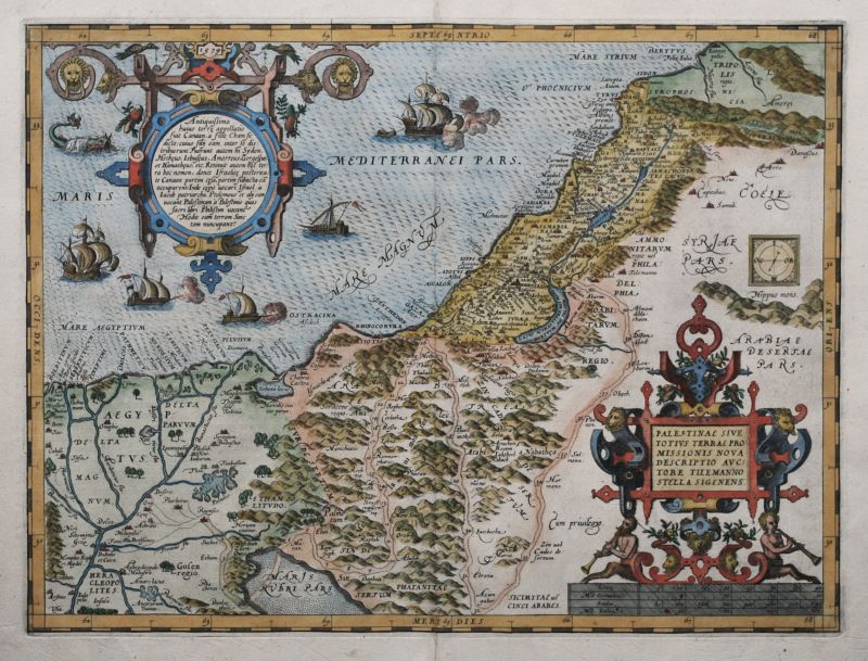
Holy Land
- Palestinae sive totius Terrae Promissionis…
- Sold
- Region: Asia
- Cartographer: Ortelius, Abraham
Holy Land
- Typus Chorographicus, Celebrium Locorum In Regno Judae Et Israhel
- Sold
- Region: Asia
- Cartographer: Ortelius, Abraham
Holy Land
- Canaan
- Sold
- Region: Asia
- Cartographer: Speed, John
Holy Land
- A Pisgah-Sight of Palestine…
- Sold
- Region: Asia
- Cartographer: Fuller, Thomas
Invasions of England and Ireland
- The Invasions of England and Ireland with al their Civill Wars since the Conquest
- Sold
- Region: England, General British Isles Maps
- Cartographer: Speed, John
Invasions of England and Ireland
- The Invasions of England and Ireland with al their Civill Wars since the Conquest
- Sold
- Region: England, General British Isles Maps
- Cartographer: Speed, John
Invasions of England and Ireland
- The Invasions of England and Ireland with al their Civill Wars since the Conquest
- Sold
- Region: General British Isles Maps
- Cartographer: Speed, John
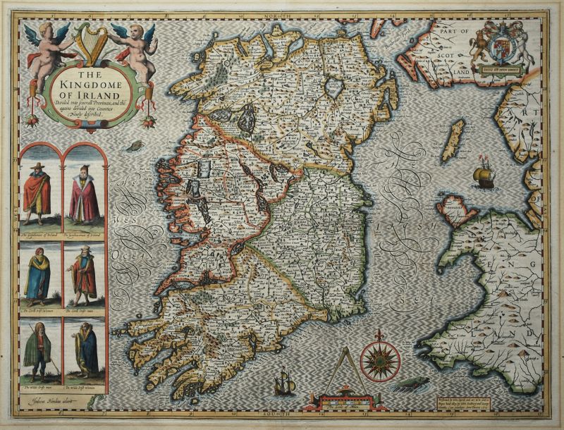
Ireland
- The Kingdome of Irland
- Sold
- Region: Ireland
- Cartographer: Speed, John
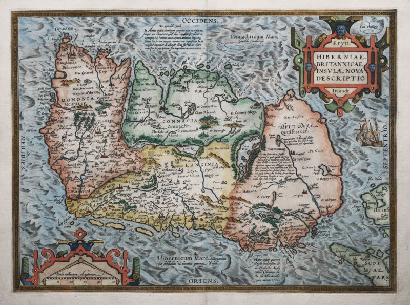
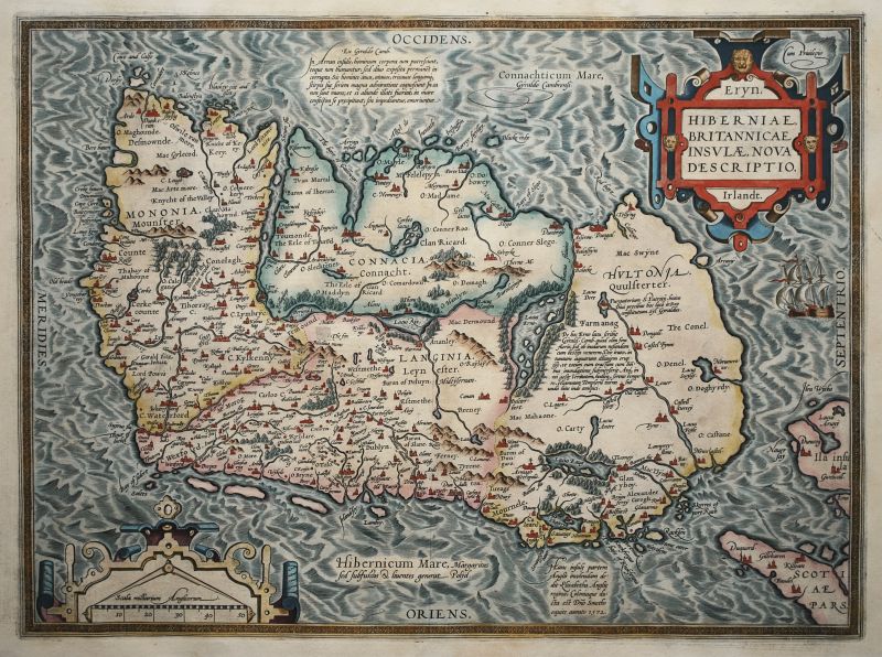
Ireland
- Hiberniae Britannicae Insula Nova Descriptio.
- Sold
- Region: Ireland
- Cartographer: Ortelius, Abraham
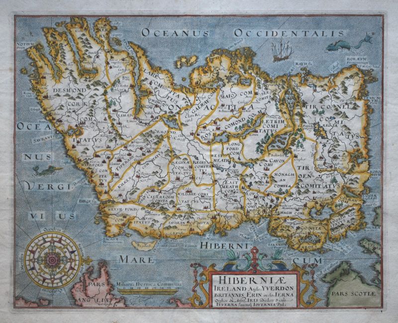
Ireland
- Hiberniae Ireland Anglis.
- Sold
- Region: Ireland
- Cartographer: Mercator, Gerard and Rumold, Hole, William
Ireland
- Hiberniae Britannicae Insula Nova Descriptio.
- Sold
- Region: Ireland
- Cartographer: Ortelius, Abraham
Ireland
- Hiberniae Britannicae Insula Nova Descriptio.
- Sold
- Region: Ireland
- Cartographer: Ortelius, Abraham
Irish Sea - Sea Chart
- Nieuwe Pas-kaert Vande oost Kust van Yrland, Beginnende van de hoeck van Waterfoort…
- Sold
- Region: Scotland, Ireland, Wales, Islands & Sea Charts
- Cartographer: van Keulen, Johannes & Gerard
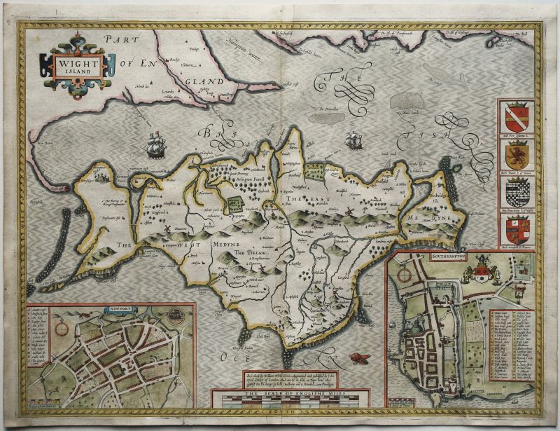
Isle of Wight
- Wight Island
- Sold
- Region: England, Hampshire, Islands & Sea Charts
- Cartographer: Speed, John
Italy
- Italia newly augmented by I. Speede
- Sold
- Region: Europe
- Cartographer: Speed, John
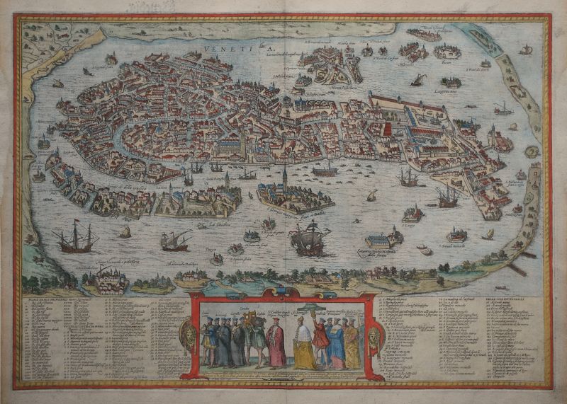
Italy - Venice
- Venetia
- Sold
- Region: Europe
- Cartographer: Braun & Hogenberg
Jerusalem
- Ierusalem
- Sold
- Region: Asia
- Cartographer: Dapper, Olfert
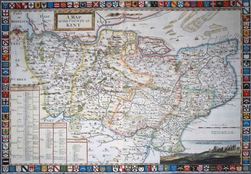
Kent
- A Map of the County of Kent
- Sold
- Region: Kent
- Cartographer: Harris, John
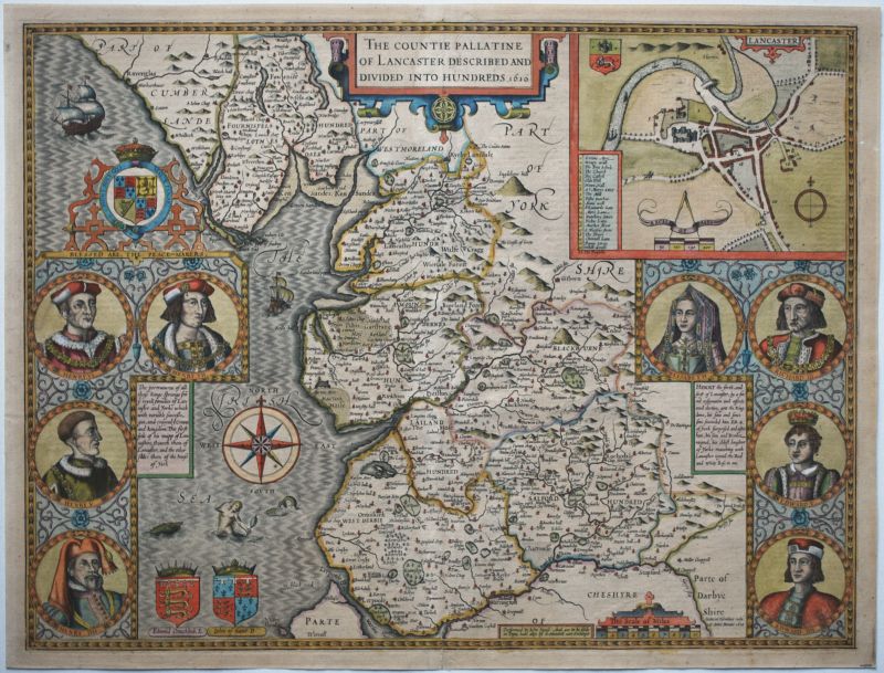
Lancashire
- The Countie Pallatine of Lancaster Described and Divided into Hundreds
- Sold
- Region: Lancashire
- Cartographer: Speed, John
Lancashire
- Lancastriae Comitatus Palintinus olim pars Brigantum
- Sold
- Region: Lancashire
- Cartographer: Saxton, Christopher, Hole, William
Lancashire
- The Countie Pallatine of Lancaster Described and Divided into Hundreds
- Sold
- Region: Lancashire
- Cartographer: Speed, John
London
- Wonderground Map of London Town
- Sold
- Region: Cities & Towns
- Cartographer: Gill, MacDonald
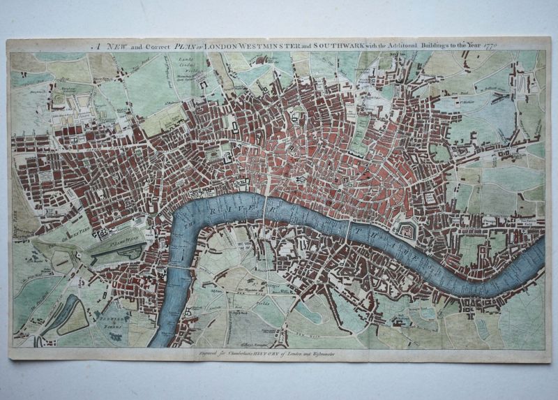
London
- A New and Correct Plan of London Westminster and Southwark with the Additional Buildings to the Year 1770.
- Sold
- Region: Cities & Towns
- Cartographer: Flyn, J.
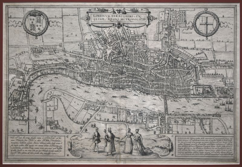
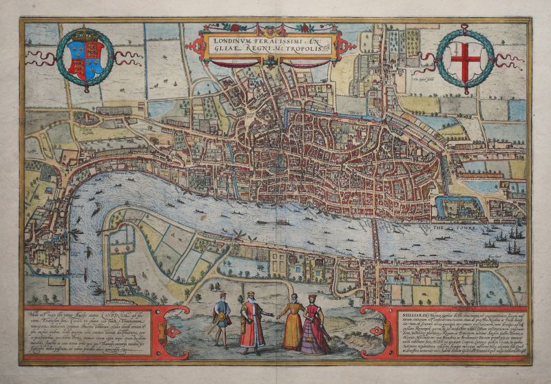
London
- Londinum Feracissimi Angliae Regni Metropolis
- Sold
- Region: Cities & Towns
- Cartographer: Braun & Hogenberg
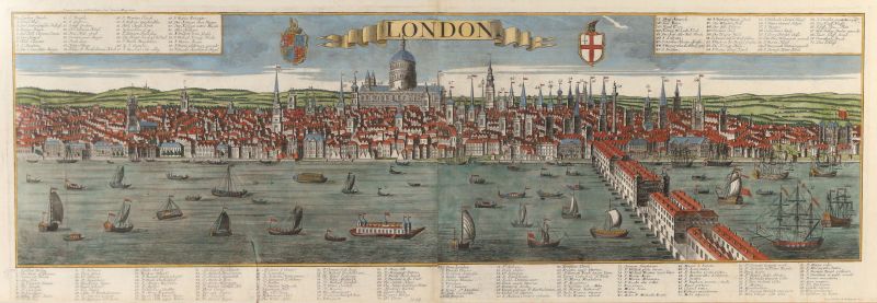
London
- London
- Sold
- Region: Cities & Towns
- Cartographer: Probst, Georg Balthasar, Werner, Friedrich Bernard
London
- London
- Sold
- Region: Cities & Towns
- Cartographer: Schiller, David
London
- Londinum Feracissimi Angliae Regni Metropolis (state 2)
- Sold
- Region: Cities & Towns
- Cartographer: Braun & Hogenberg
London
- Londinum Feracissimi Angliae Regni Metropolis (2nd state)
- Sold
- Region: Cities & Towns
- Cartographer: Braun & Hogenberg
London
- New Map of London
- Sold
- Region: Cities & Towns
- Cartographer: Belch, William, Langley, Edward
London - Westminster
- A New and Accurate Plan of the City of Westminster…
- Sold
- Region: Cities & Towns
- Cartographer: Cole, Benjamin
London and Middlesex
- An Actuall Survey of Midlesex
- Sold
- Region: Cities & Towns, Middlesex
- Cartographer: Ogilby, John
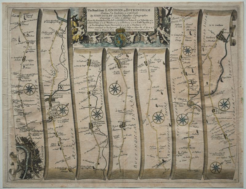
London to Banbury
- The Road from London to Buckingham – Plate # 12
- Sold
- Region: Road Maps
- Cartographer: Ogilby, John
Low Countries
- Belgii Veteris Typus.
- Sold
- Region: Europe
- Cartographer: Ortelius, Abraham
Maryland, Virginia & Carolinas
- Virginia, Marylandia et Carolina…
- Sold
- Region: Americas
- Cartographer: Homann, Johann Baptist & Heirs
Mexico and Central America
- Yucatan Conventus Iuridici Hispaniae Novae Pars Occidentalis, et Guatimala Conventus Iuridicus
- Sold
- Region: Americas
- Cartographer: Blaeu, Willem & Joan
Middlesex
- MIDLE-SEX described with the most famous Cities of London and Westminster
- Price: £500.00 ($665.00)
- Region: Middlesex
- Cartographer: Speed, John
Munster
- The Province of Mounster
- Sold
- Region: Ireland
- Cartographer: Speed, John
Munster
- The Province of Mounster
- Sold
- Region: Ireland
- Cartographer: Speed, John
Munster
- The Province of Mounster
- Sold
- Region: Ireland
- Cartographer: Speed, John
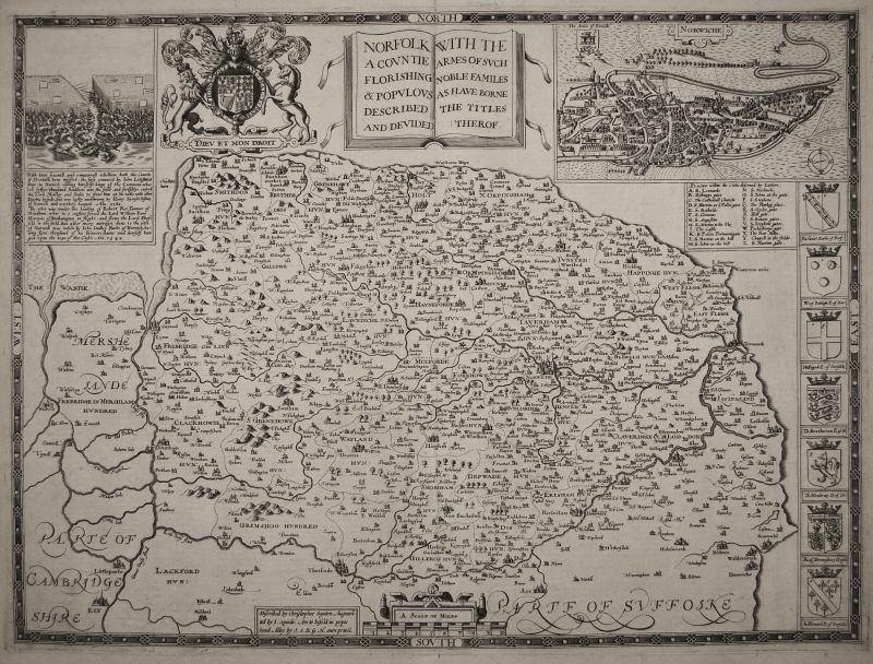
Norfolk
- Norfolk A Countie Florishing & Populous Described…
- Sold
- Region: Norfolk
- Cartographer: Speed, John
North Atlantic and Scandinavia
- Septentrionalium Regionum Descrip.
- Sold
- Region: Europe
- Cartographer: Ortelius, Abraham
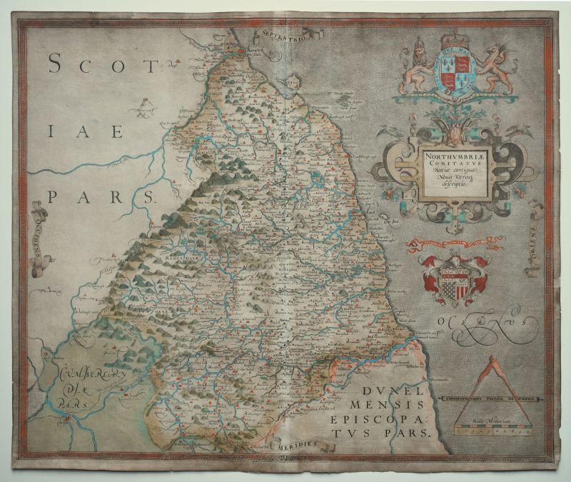
Northumberland
- Northumbriae Comitatus (Scotiae contiguae) Nova Veraq descriptio.
- Sold
- Region: Northumberland
- Cartographer: Saxton, Christopher
Nottinghamshire
- The Countie of Nottingham Described…
- Sold
- Region: Nottinghamshire
- Cartographer: Speed, John
Oxford
- Prospectus Oxoniae Orientalis / Prospectus Oxoniae Meridionalis
- Sold
- Region: Cities & Towns
- Cartographer: Loggan, David
Oxford
- Nova & Accuratissima Celeberrimae Universitatis Civitatisque Oxoniensis Scenographia
- Sold
- Region: Cities & Towns
- Cartographer: Loggan, David
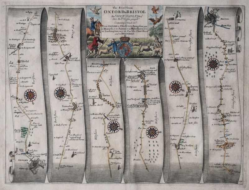
Oxford to Bristol
- The Road from Oxford to Bristol – Plate # 79
- Sold
- Region: Road Maps
- Cartographer: Ogilby, John
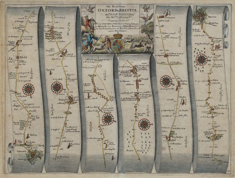
Oxford to Bristol
- The Road from Oxford to Bristol – Plate # 79
- Sold
- Region: Road Maps
- Cartographer: Ogilby, John
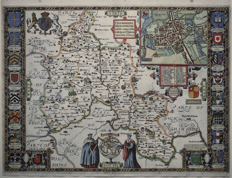
Oxfordshire
- Oxfordshire described with ye Citie and the Arms of the Colledges of ye famous University.
- Sold
- Region: Oxfordshire
- Cartographer: Speed, John
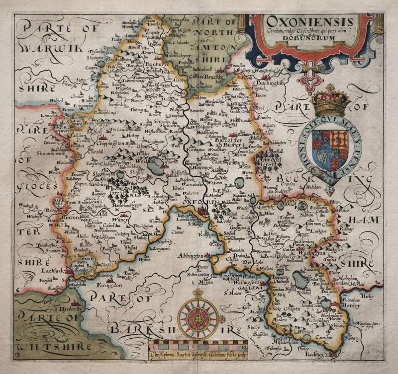
Oxfordshire
- Oxonium Comitatus, Vulgo Oxford Shire.
- Sold
- Region: Oxfordshire
- Cartographer: Blaeu, Willem & Joan
Oxfordshire
- Oxfordshire described with ye Citie and the Arms of the Colledges of ye famous University.
- Sold
- Region: Oxfordshire
- Cartographer: Speed, John
Oxfordshire
- Oxoniensis Comitatus, vulgo Oxfordshyre
- Sold
- Region: Oxfordshire
- Cartographer: Saxton, Christopher, Hole, William
Oxfordshire
- Oxoniensis Comitatus, vulgo Oxfordshyre
- Sold
- Region: Oxfordshire
- Cartographer: Saxton, Christopher, Hole, William
Oxfordshire
- Oxfordshire described with ye Citie and the Arms of the Colledges of ye famous University.
- Sold
- Region: Oxfordshire
- Cartographer: Speed, John
Oxfordshire, Buckinghamshire & Berkshire
- Oxford Buckingham & Barkshire
- Sold
- Region: Berkshire, Oxfordshire, Buckinghamshire
- Cartographer: Saxton, Christopher, Willdey, George
Pacific Ocean
- Maris Pacifici (quod vulgo Mar del Zur)…
- Sold
- Region: Africa & Oceana, Americas, Asia
- Cartographer: Ortelius, Abraham
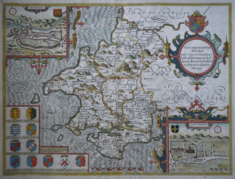
Pembrokeshire
- Penbrokeshire described And The Situations both of Penbroke and St. Davids…
- Sold
- Region: Wales
- Cartographer: Speed, John
Pembrokeshire
- Penbrokeshire described And The Situations both of Penbroke and St. Davids…
- Sold
- Region: Wales
- Cartographer: Speed, John
Pembrokeshire
- Penbrokeshire described And The Situations both of Penbroke and St. Davids…
- Sold
- Region: Wales
- Cartographer: Speed, John
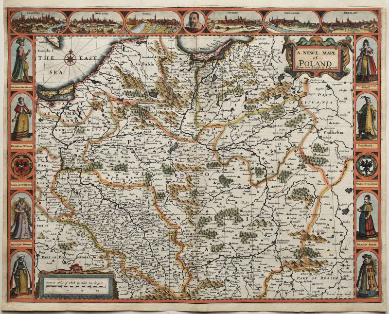
Poland
- A Newe Mape of Poland
- Sold
- Region: Europe
- Cartographer: Speed, John
Poland
- Carte De Pologne Avec La Chronologie Des Rois…
- Sold
- Region: Europe
- Cartographer: Chatelain, Henri Abraham
Roman Empire - Europe, Asia & Africa
- A New Mappe of the Romane Empire
- Sold
- Region: Africa & Oceana, Europe, Asia
- Cartographer: Speed, John
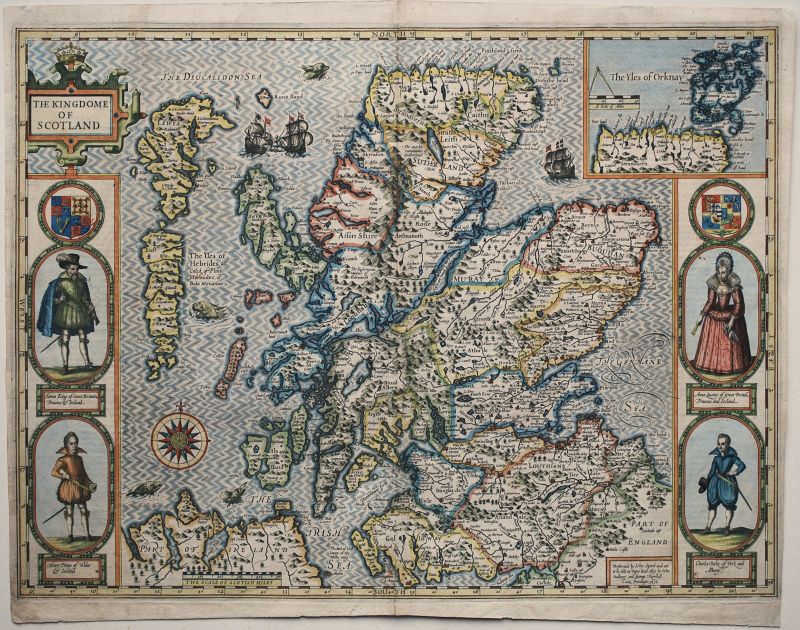
Scotland
- The Kingdome of Scotland
- Sold
- Region: Scotland
- Cartographer: Speed, John
Scotland
- Scotia Regnum
- Sold
- Region: Scotland
- Cartographer: Mercator, Gerard and Rumold
Scotland
- The Kingdome of Scotland
- Sold
- Region: Scotland
- Cartographer: Speed, John
Scotland
- The Kingdome of Scotland
- Sold
- Region: Scotland
- Cartographer: Speed, John
Scotland
- The Kingdome of Scotland
- Sold
- Region: Scotland
- Cartographer: Speed, John
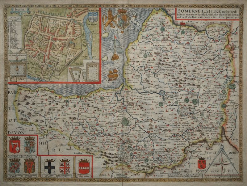
Somerset
- Somersetshire Described ãd into Hundreds devided…
- Sold
- Region: Somerset
- Cartographer: Speed, John
Somerset
- Somersetshire Described ãd into Hundreds devided…
- Sold
- Region: Somerset
- Cartographer: Speed, John
Somerset
- Somersettensis Comitatus. Somerset Shire.
- Sold
- Region: Somerset
- Cartographer: Blaeu, Willem & Joan
Somerset
- Somersetensem Comitat (agri fertilitate Celebrem) hec ob oculos ponit Tabula
- Sold
- Region: Somerset
- Cartographer: Saxton, Christopher
Somerset & Wiltshere
- Somersetshere and Wiltshere
- Sold
- Region: Somerset, Wiltshire
- Cartographer: Drayton, Michael
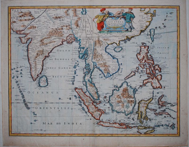
South-East Asia
- A New Map of East India
- Sold
- Region: Asia
- Cartographer: Speed, John
South-East Asia
- A New Map of East India
- Sold
- Region: Asia
- Cartographer: Speed, John
Southwest Coast of England
- Carte Maritime de L'Angleterre depuis les Sorlingues jusques à Portland...
- Sold
- Region: England, Cornwall, Devon, Islands & Sea Charts
- Cartographer: Hooghe, Romeyn de
Spain
- Spaine Newly described…
- Sold
- Region: Europe
- Cartographer: Speed, John
Spain and France
- Pas Caart van de Bocht van Vranckryck Biscaien en Galissen tusschen Heyssant en C. de Finisterre.
- Sold
- Region: Europe
- Cartographer: van Keulen, Johannes & Gerard
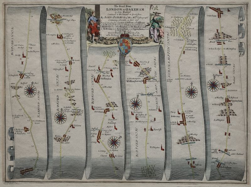
St. Albans to Oakham
- The Road from London to Oakeham – Plate # 47
- Sold
- Region: Road Maps
- Cartographer: Ogilby, John
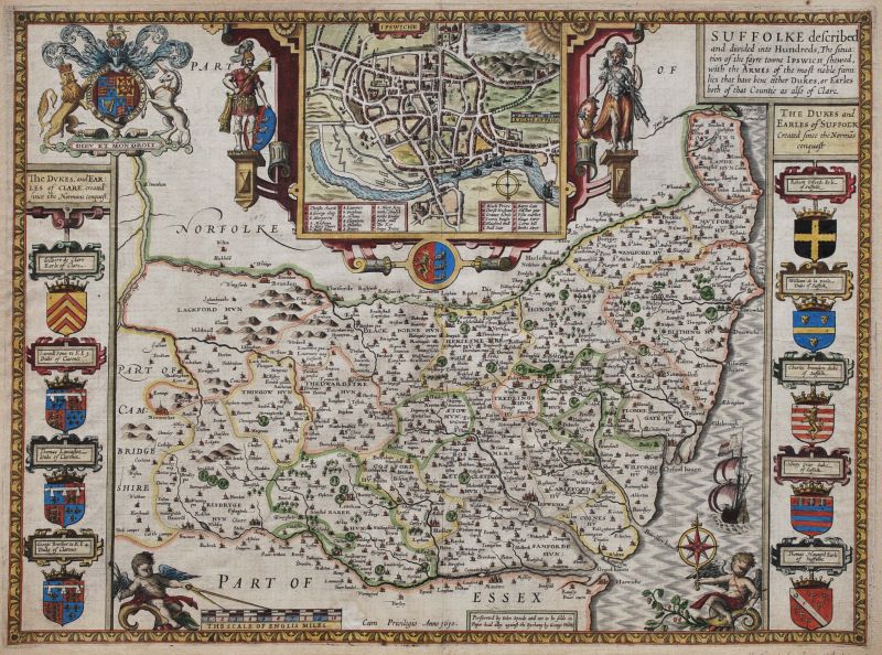
Suffolk
- Suffolke described and divided into Hundreds …
- Sold
- Region: Suffolk
- Cartographer: Speed, John
Suffolk
- Suffolciae Comitatus continens in Se Oppida mercatoria 25, Pagos et Villas 464, Una cum Singulis Hundredis & fluminibus in eodem Vera descriptio. Anno Domini 1575
- Sold
- Region: Suffolk
- Cartographer: Saxton, Christopher
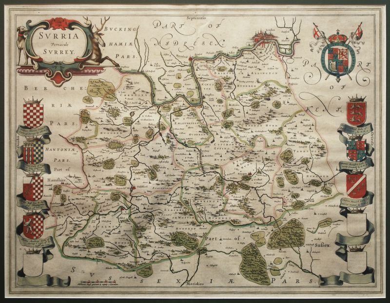
Surrey
- Surrey olim sedes Regnorum
- Sold
- Region: Surrey
- Cartographer: Kip, William, Norden, John
Surrey
- Surrey Described and Divided into Hundreds
- Sold
- Region: Surrey
- Cartographer: Speed, John
Surrey
- Surria Vernacule Surrey.
- Sold
- Region: Surrey
- Cartographer: Blaeu, Willem & Joan
Sussex
- Sussex Described and divided into Rapes with the situation of Chichester…
- Sold
- Region: Sussex
- Cartographer: Speed, John
Sussex
- Sussex Described and divided into Rapes with the situation of Chichester…
- Sold
- Region: Sussex
- Cartographer: Speed, John
Sussex
- Sussex Described and divided into Rapes with the situation of Chichester…
- Sold
- Region: Sussex
- Cartographer: Speed, John
Ulster
- The Province of Ulster described.
- Sold
- Region: Ireland
- Cartographer: Speed, John
Ulster
- The Province of Ulster described.
- Sold
- Region: Ireland
- Cartographer: Speed, John
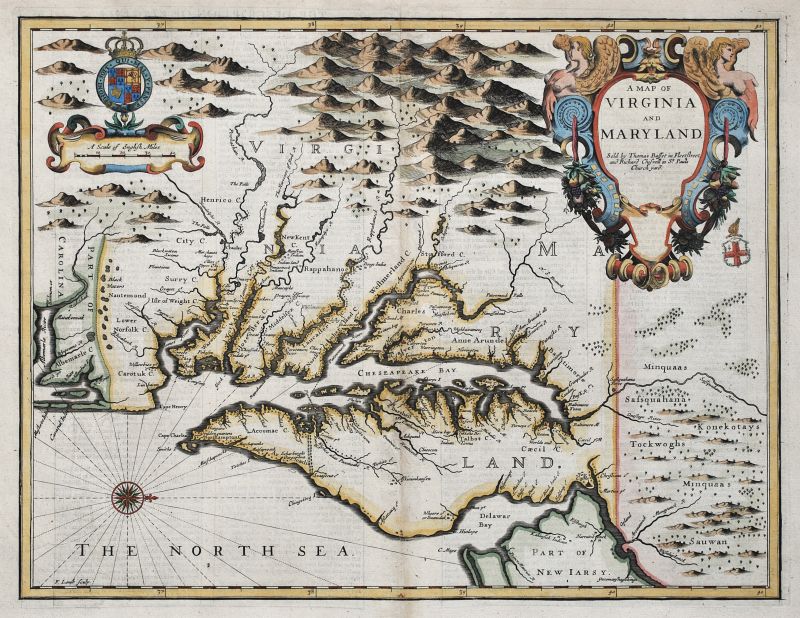
Virginia and Maryland
- A Map of Virginia and Maryland
- Sold
- Region: Americas
- Cartographer: Speed, John
Virginia and Maryland
- A New Map of Virginia Maryland And The Improved Parts of Pennsylvania & New Jersey.
- Sold
- Region: Americas
- Cartographer: Senex, John
West Indies
- Insulae Americanae in Oceano Septentrionali…
- Sold
- Region: Americas
- Cartographer: Visscher, Nicolaes
Westmorland & Cumberland
- Westmorlandiae Et Cumberlandiae…
- Sold
- Region: Cumberland, Westmorland
- Cartographer: Saxton, Christopher
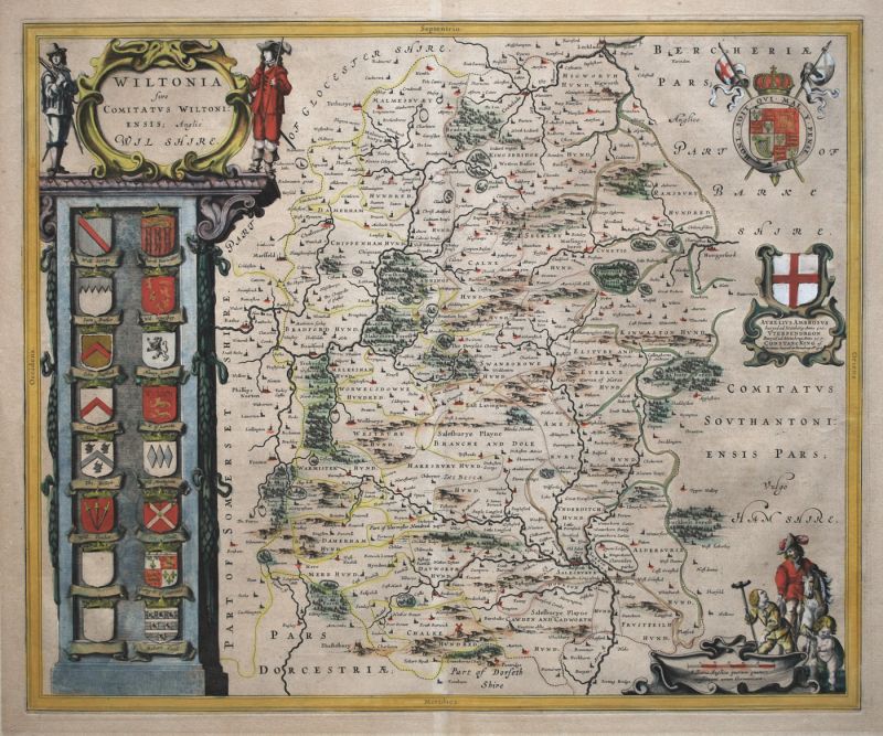
Wiltshire
- Wiltonia Sive Comitatus Wiltoniensis; Anglis Wiltshire.
- Sold
- Region: Wiltshire
- Cartographer: Blaeu, Willem & Joan
Worcestershire
- Worcestershire
- Sold
- Region: Worcestershire
- Cartographer: Speed, John
World
- Diversi Globi Terr-Aquei…
- Sold
- Region: World & Celestial
- Cartographer: Seutter, Mattheus
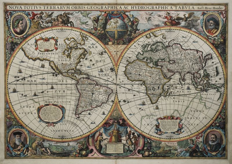
World
- Nova Totius Terrarum Orbis Geographica Ac Hydrographica Tabula
- Sold
- Region: World & Celestial
- Cartographer: Hondius, Jodocus & Henricus
World
- Novissima Totius Orbis Tabula. Per Carolum Allard.
- Sold
- Region: World & Celestial
- Cartographer: Allard, Carel
World
- Mappa-Monde Carte Universelle De La Terre…
- Sold
- Region: World & Celestial
- Cartographer: Nolin, Jean Baptiste, Denis, Louis
Yorkshire - North & East Ridings
- The North and East Ridins of Yorkshire
- Sold
- Region: Yorkshire
- Cartographer: Speed, John